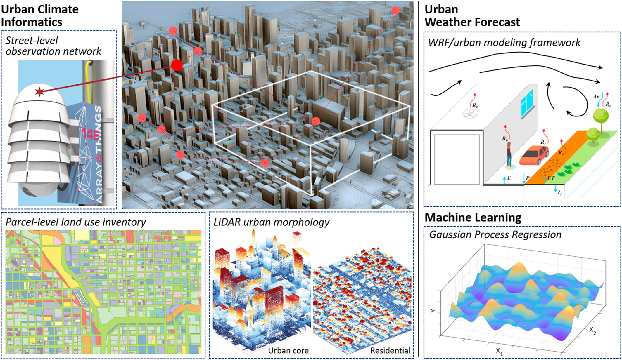
A new modeling framework for predicting street-level temperatures and enhancing urban planning and public health strategies.
The Science
Predicting detailed weather down to the air temperature on city streets is challenging due to urban areas’ complex environments. The traditional methods for modeling land surface conditions in urban areas involve a lot of computing power and are inefficient. This study introduces a way to estimate hourly air temperature on city streets. It combines traditional weather modeling with machine learning and advanced environmental monitoring networks. Tested in Chicago, a team of researchers successfully estimated air temperature at a very detailed level.

The Impact
The study unifies past research on urban environments with new techniques like machine learning and urban climate informatics—the collection and use of climate data and urban information. This research enhances the development of new urban climate models and guides city observations. Being able to estimate temperatures very locally is useful for urban planning, reducing the urban heat island effect, and protecting public health. City planners and architects can use this data to design buildings that improve airflow and cool spaces. Overall, accurate temperature information leads to more effective city planning and makes cities safer and more comfortable to live in.
Summary
Estimating air temperature at street level is difficult because of the complex environment in cities and the limitations of current urban numerical models. With the rapid development of data collection and analysis techniques in recent years, advanced machine learning algorithms can fully utilize hyper-local data harvested from urban areas.
This study proposes a modeling method to estimate point-scale street-level air temperature from a conventional urban weather model and a suite of hyper-resolution urban data sets. These data sets were collected using state-of-the-art techniques, such as submeter-level light detection and ranging technology and wireless weather observation networks. The proposed approach vastly improves the resolution of temperature predictions through an application to Chicago.
The modeling results have multiple real-world applications, such as providing navigation suggestions to reduce pedestrians’ thermal discomfort. Moreover, the model can be expanded to other areas given the current data availability. Study results can also help the development of next-generation urban climate and weather models and guide observation efforts in cities, which together can build a holistic understanding of urban microclimate dynamics.
PRINCIPAL INVESTIGATOR
Ashish Sharma
Discovery Partners Institute at the University of Illinois System and Argonne National Laboratory
[email protected]
PROGRAM MANAGER
Sally McFarlane
U.S. Department of Energy,
Biological and Environmental Research (SC-33)
Urban Integrated Field Laboratories
[email protected]
Funding
This work is supported by the Biological and Environmental Research program within the U.S. Department of Energy’s Office of Science under contract DE-AC02-06CH11357. This research is supported by the Walder Foundation; National Science Foundation awards 2139316, 2230772, and 2330565; and NASA award #80NSSC22K1683.
High-performance computing support was received from the Cheyenne (DOI:10.5065/D6RX99HX) and Derecho supercomputers (DOI:10.5065/qx9a-pg09) provided by National Center for Atmospheric Research’s Computational and Information Systems Laboratory.
References
Li, P., and A. Sharma. “Hyper-Local Temperature Prediction Using Detailed Urban Climate Informatics.” Journal of Advances in Modeling Earth Systems 16 (3), e2023MS003943 (2024). https://doi.org/10.1029/2023MS003943.


